



Jammu: Sonamarg, a picturesque place in central Kashmir’s Ganderbal district, received the season’s first snowfall on Monday, even as widespread rains lashed the Valley and several parts of Jammu division, prompting authorities to issue a high alert amid multiple incidents of cloudbursts and extreme weather.
Intermittent rainfall continued throughout the day, bringing down the mercury across Kashmir. The upper reaches of Sonamarg witnessed light snowfall, marking the season’s first whiteout.
The Meteorological department (MeT) said Qazigund, the gateway of Kashmir, recorded the highest rainfall with 25.0 mm, followed by 19.0 mm in Kokernag. Srinagar received 17.2 mm till 05:30 PM, Gulmarg 16.4 mm, and Pahalgam 17.0 mm, while 10.7 mm was recorded till evening.
In Jammu division, Banihal recorded 16.0 mm of rainfall, Bhaderwah 5.0 mm, Katra 4.6 mm, and Batote 1.7 mm. Flash floods were reported in the Ajas area of Bandipora, though officials clarified that there was no flood threat elsewhere in the Valley.
The water level in Jhelum and multiple streams has increased but remains under control, with continuous monitoring underway.
The MeT department has predicted light to moderate rain and thunder at most places with intense showers and heavy rainfall in parts of Jammu division, especially Reasi, Udhampur, Rajouri, Poonch, Samba and Kathua, along with moderate to heavy rains in Doda, Kishtwar, Ramban and a few areas of Kashmir division till tomorrow.
From August 20 to 22, generally hot and humid weather with brief thundershowers is expected, followed by more rains between August 23 and 25.
Meanwhile, amid multiple incidents of cloudbursts in recent weeks, authorities have stepped up disaster preparedness across Jammu and Kashmir.
Officials from the J&K Disaster Management Authority (JKDMA) said that preparedness protocols remain on standby and are fully activated during active weather alerts.
Measures include round-the-clock Emergency Operation Centers, CAP Sachet alerts, district-level disaster management plans, pre-positioning of responders, and supervision at the highest administrative level through Chief Secretary-led Incident Response System (IRS) meetings.
The pan-India helpline 112 has also been further strengthened.
According to the India Meteorological Department (IMD), J&K recorded several “extremely heavy rainfall events” over the past week.
On 12th August, Reasi district received 204 mm at one station and 284 mm and 234 mm at two others in 24 hours, with nearby areas like Udhampur (166 mm) and Samba (102 mm) also recording extreme rainfall.
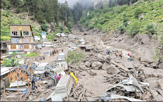
The IMD confirmed that the tragic Kishtwar event on August 14, which left over 60 dead and more than 80 injured, qualifies as a cloudburst.
Similarly, Kathua district saw three stations record 91 mm, 95 mm, and 97 mm within less than two hours, leaving seven people dead.
Officials noted that cloudbursts, defined as rainfall exceeding 100 mm in an hour in hilly terrain, are considered extreme due to their intensity and topography, often leading to sudden flooding and debris flow, as witnessed in Kishtwar.
The administration has mobilised early warning systems and intensified awareness campaigns among vulnerable communities.
“We are scaling up preparedness across all districts. Cloudbursts cannot be prevented, but their impact can be minimised through early alerts and swift response,” a JKDMA official said.
The MeT has cautioned that cloudbursts, flash floods, landslides, mudslides and shooting stones remain possible in vulnerable areas.
People have been advised to stay away from streams, riverbanks, loose structures and unsafe houses, while travellers, tourists and trekkers have been urged to plan journeys carefully.

